The Rough Fire is finally getting close to over. See below. For the incident page go here.
Final Press Release
Rough Fire Final Update
Incident: Rough Fire Wildfire
Released: 5 days ago
Date Started: July 31, 2015 Cause: Lightning Size: 151,623 acres Containment: 95%
Structures Destroyed: 4
Firefighter injuries to date: 12
Total Personnel: 153
Fire Resources: 4 crews, 3 engines, 2 helicopters, 4 bulldozers, 8 water tenders
FIRE SUMMARY: Cooler weather and wetting rain was received over parts of the fire last weekend, aiding firefighters with suppression efforts. Fire crews are continuing to patrol and mop-up areas within the perimeter of the fire. A Burned Area Emergency Response (BAER) Team is nearly complete with their assessment of long-term threats to life, property, water quality and deteriorated ecosystems from further damage.
North Zone, Sierra National Forest: Fire Information (559) 297-0706
All areas within the North Zone are in patrol status by air and ground resources.
South Zone, Sequoia National Forest: Fire Information- Denise Alonzo (559) 539-2607 ext. 72212Command of the South Zone will be transitioned to a local Type 4 team as of October 10 at 8 a.m. This locally administered team is comprised of mostly Hume Lake Ranger District employees. They will work from the current ICP at the North America/Armenian Church Camp until Tuesday 10/13 when they move the command post to the Forest Service work center in Pinehurst. Firefighters continue to be released from the fire to their home units and families.
South Zone, Sequoia and Kings Canyon National Parks: Fire Information – Mike Theune (559) 565-3703
Currently park managers are working with fire staff, local and state government agencies, and other stakeholders to make assessments of the area. This includes a specialized fire response group known as a BAER (Burned Area Emergency Response) Team which looks at short-term and long-term effects the fire had on the ecosystem and infrastructure.Area Closures: Area closures for public and firefighter safety remain in place on the Sequoia and Sierra National Forests, Giant Sequoia National Monument, and Kings Canyon National Park. For more information please contact the persons listed above for the area you wish to visit.Additional information (photos, maps, and past documents) can be found at:http://inciweb.nwcg.gov/incident/4456/ this will be the final update unless conditions warrant.
10/14/2015 Incident Update
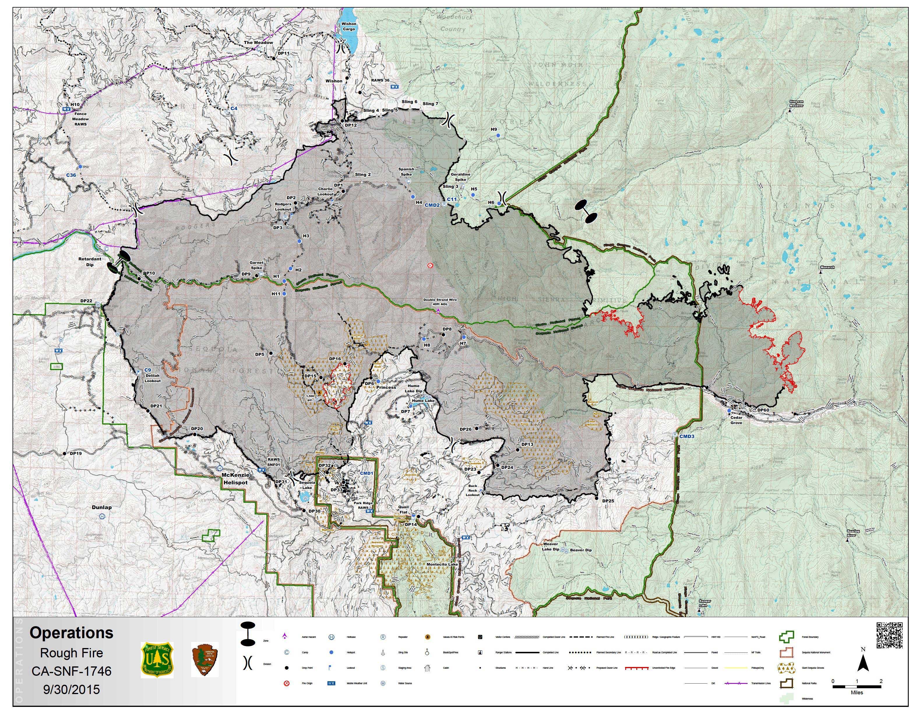
Map at Inci: [ Enlarge ] [ Full Size ]
Warmer and dryer air moved into the area this week with above average temperatures, but firefighters were able to mop up hot spots and keep containment of the fire. Fire crews are continuing to patrol and mop-up areas within the perimeter of the burn. A Burned Area Emergency Response (BAER) Team assessed the burned area for long-term threats to life, property, water quality and deteriorated ecosystems from further damage.
Recreation Update for the South Zone: The Rough Fire is nearing containment where it burned on the Hume Lake Ranger District in Giant Sequoia National Monument, Sequoia National Forest. Even though the threat of fire is diminishing, the effects of that fire and suppression activities are keeping most of the District closed for public safety.
Currently, the Eshom and Stony Creek areas south of Highway 180, west of the Generals Highway, are open for recreation, including hunting. The road leading into Hume Lake from Highway 180 and the Generals Highway (Tenmile road) may be reopened in 2-3 weeks. Barriers need to be installed on secondary roads leading from the Tenmile road prior to this route to Hume Lake being reopened for winter activity.
The rest of the Hume Lake Ranger District will remain closed for the rest of this season. This includes Big Meadows, Millwood, Delilah, McKenzie Ridge, Converse Basin, and the Jennie Lakes Wilderness. There are still hot spots smoldering in the burned area, trees that may fall having been weakened by fire, and rolling debris loosened from burned vegetation.
Recreation area opening procedures in the springtime typically require weeks of preparation before an area can be open to visitors. “With that in mind, and the normal recreation season ending in mid-November, I have decided to keep these areas closed until next season,” stated District Ranger Teresa Benson. “With the fire suppression repair work ongoing on the District, even those areas that were not actually burned in the Rough fire are being affected by our activities.”
“We appreciate the patience and understanding of hunters who have traditionally hunted within the closed area for abiding by the closure as firefighters continue to secure the perimeter and conduct suppression repair,” stated Benson. Individuals who currently hold a permit for entry or who have permission to access their property will be allowed to do so. However, they will only be given access to their property; these permits do not give access to recreate in the closed areas.
Sequoia National Forest Information (559) 539-2607 ext. 72212
Sierra National Forest Information (559) 297-0706.
Kings Canyon National Park Information (559) 565-3703
Further updates will occur when there is significant information to report
SIERRA NATIONAL FOREST CLOSURE ORDER
SEQUOIA NATIONAL FOREST CLOSURE ORDER
Breakdown of Acreage by Ownership:
Kings Canyon National Park: 9,413 Acres
Sequoia National Forest: 82,573 Acres
Sierra National Forest: 58,541 Acres
State Lands: 6 Acres
Private Lands: 1,090 Acres
Basic Information
| Current as of | 10/14/2015, 8:08:42 AM |
|---|---|
| Incident Type | Wildfire |
| Cause | Lightning/natural |
| Date of Origin | Friday July 31st, 2015 approx. 07:00 PM |
| Location | 5 miles North of Hume Lake and 2.5 miles to the southwest of Spanish Mountain5 |
| Incident Commander | Joe Domingo, ICT4 South Zone, Brian Vasquez, ICT4 North Zone |
| Incident Description | Wildfire |
Current Situation
| Total Personnel | 50 |
|---|---|
| Size | 151,623 Acres |
| Percent of Perimeter Contained | 95% |
| Fuels Involved | Timber (Litter and Understory |
Outlook
| Planned Actions | **South Zone: Continue to patrol the burned area. Suppression repair work ongoing.
**North Zone: Patrol fire line as needed. |
|---|---|
| Remarks | Breakdown of Acreage by Ownership:
Sequoia National Forest: 82,573 acres Sierra National Forest: 58,541 Kings Canyon National Park: 9,413 acres State Lands: 6 acres Private Lands: 1,090 acres |