#1 At-Risk Community
Cascadel Ranch is a densely populated former ranch that dates back to the nineteenth century.
Before that, Cascadel Ranch was the indigenous peoples. Called Hoya Kwe by the local tribe, Cascadel Ranch is both ecologically and culturally rich.
The CWPP names Cascadel Ranch as the number one at-risk community for catastrophic wildfire.
Steep, Rugged, Dangerous: Plus a Valley
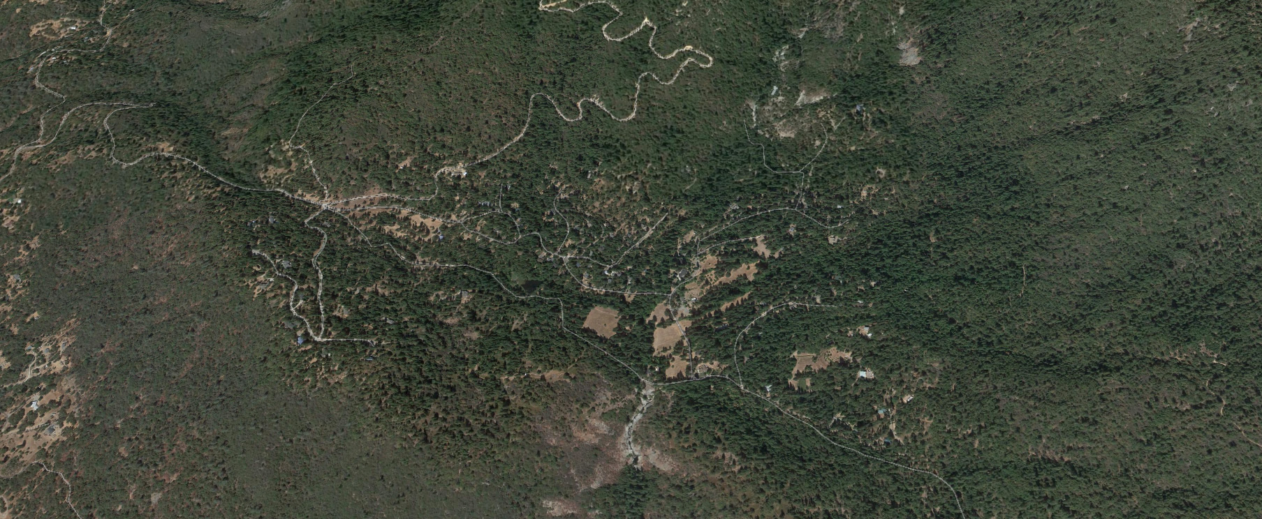
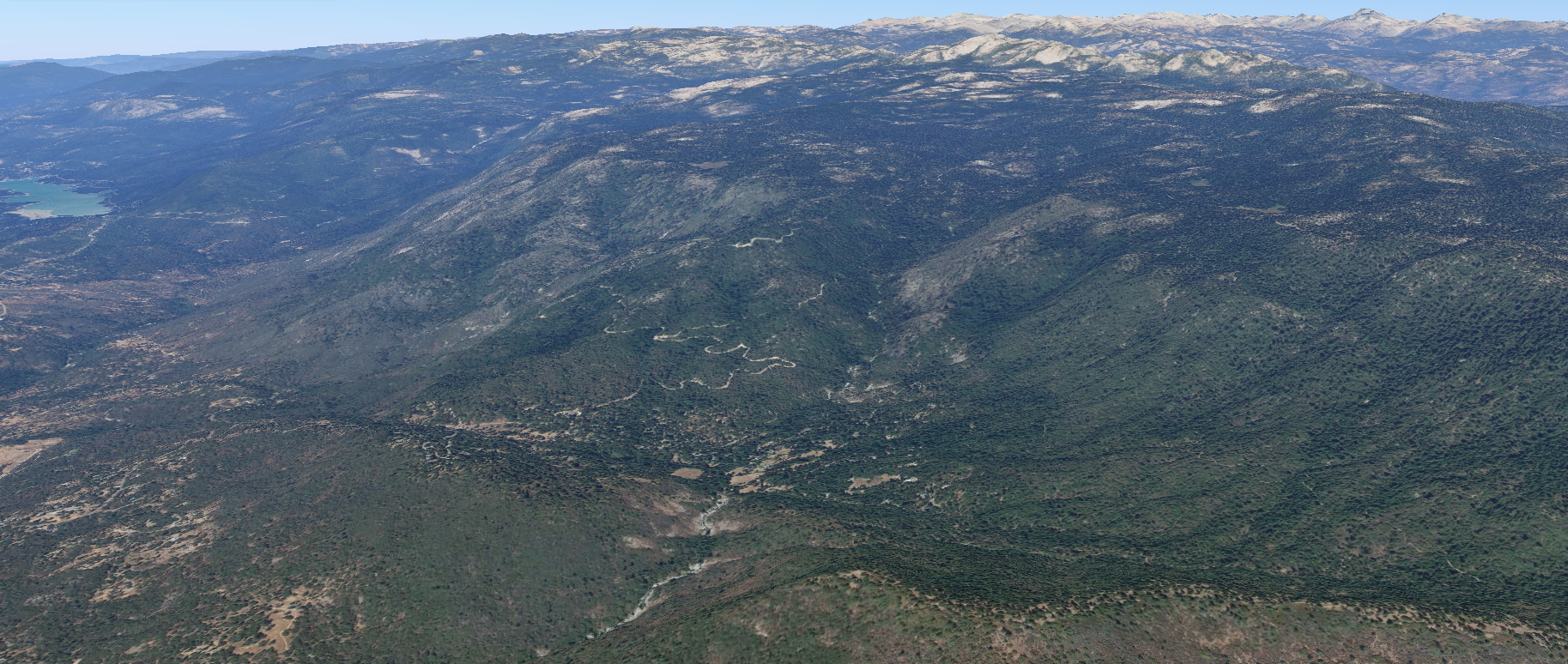
Cascadel Ranch is 480 acres of rugged steep heavily vegetated terrain completely encircled by Sierra National Forest at around 3800 feet elevation.
The ranch is approximately bisected by Whisky Creek part of the greater Willow Creek San Joaquin River Watershed.
The entire area is sensitive riparian watersheds and wetlands.
The valley in the center is wild riparian meadows near the middle of the ranch.
There is an old lodge dating back to the early twentieth century.
The 40 acres of open space valley is now county owned public open space that attracts many tourists and local users.
High Density
Starting in 1957, Cascadel Ranch was subdivided and parceled into around 200+- lots and parcels.
Cascadel Ranch is now made up of Cascadel Woods and the remaining surrounding acreage of Cascadel Ranch.
The southwestern area of 20 parcels are collectively known as Cascadel Heights.
All together the area is known as Cascadel or Cascadel Ranch.
Generally speaking, structure density is high, fuel load is high, and access is poor.
Cascadel Woods
Cascadel Woods is the most densely populated and dangerous area.
Three subdivisions were created in 1957 and 1963. There are about 170 lots on about 120 acres are mostly 1/3 acres lots.
Cascadel Woods is the highest risk area in Cascadel Ranch due to small lot size and poor ingress egress.
Defensible space is low or non-existent. Terrain is steep. Roads are narrow, dead end, and poorly maintained.
Cascadel Heights
Cascadel Heights is in the southwestern area of Cascadel Ranch. With 20 parcels on about 40 acres, density is lower.
Fuel load is lower. Roads are better maintained. Access is better, however, still on dead end roads.
As the name implies, Cascadel Heights is along a ridge top with great views, and great risk from wildfire.
Cascadel Ranch
Cascadel Ranch includes Cascadel Woods and Cascadel Heights.
Both are part of the original 480 acre ranch.
The areas outside of the three subdivisions and 20 parcels of Cascadel Heights, vary in density, with the largest parcel at 26 acres.
The landscape is heavily forested mixed conifer and brush. Terrain is mostly steep. Access is poor.
The only through road East of the ranch is currently blocked but accessible in emergencies.
http://www.cagenweb.com/madera/MCH-1-4hogue.html
Cascadel Ranch contains many arch sites and a unique ecology of riparian meadows and watersheds. Whisky Creek and the open space brings hundreds of tourists annually.
CWPP Cascadel Woods
Below is an excerpt from the Madera County Community Wildfire Protection Plan of 2008.
Please note that the conditions have changed since 2008. More homes have been constructed. More brush has grown. However, the Eastern Madera County Fire Safe Council did some fuel break work in the area from 2010 to 2012.
Also note that the plan refers to “Cascadel Woods” however the conditions and mitigation recommendations apply to all of Cascadel Ranch’s 480 acres.
The accuracy of the plan is presented as written in 2008 and not guaranteed.
CWPP PRIORITY #1 Community: Cascadel Woods
Location: Section 16, T8S, R23E
Population: 106 dwelling units plus numerous outbuildings
Specific Problems
- A large amount of timber fuels interspersed with heavy volumes of brush within and surrounding the community
- An approximate 3 mile narrow, windy two-lane road (Cascadel Road / Road 233) with contiguous trees and brush serves as the only reliable road in and out of the community
- Steep brush covered slopes south and east of the community
- Narrow roads with a bridge incapable of handling heavy equipment within the community
- Many older homes and cabins in close proximity to one another, some with wood shake roofs and combustible exterior construction
- A larger percentage of retired and absentee homeowners
Evacuation routes: West on Cascadel Road (Road 233), then east or west on Road 225
Past Actions
- Roadside fuel reduction and fuel-break construction along Cascadel Road by USFS
- Fuel reduction projects conducted by joint efforts of USFS, Fire Safe Council and Coarsegold Resource Conservation District in areas near the community
- Intermittent compliance inspections for PRC 4291 regulations by fire officials
Priority Mitigation Needs
- Citizen involvement to reduce fuels on their property and to utilize fire-wise construction techniques to improve structure survivability
- Identify and construct safety zones that can be used as temporary shelter-in-place areas for residents as well as fire personnel
- A 200’ to 300’ wide shaded fuel-break surrounding the community
- Continued construction and maintenance of the fuel-break along Cascadel Road
- Fuel reduction on Sierra National Forest land adjacent to community assets by the use of harvesting or thinning projects
- Implement a PRC 4291 compliance inspection program within the community
Education
Through homeowner association or town hall type meetings, develop and promote community specific programs designed to inform and involve the community on wildfire mitigation plans, escape routes, potential shelter-in-place locations, and activities that could reduce the risk to citizens, property and community assets.